
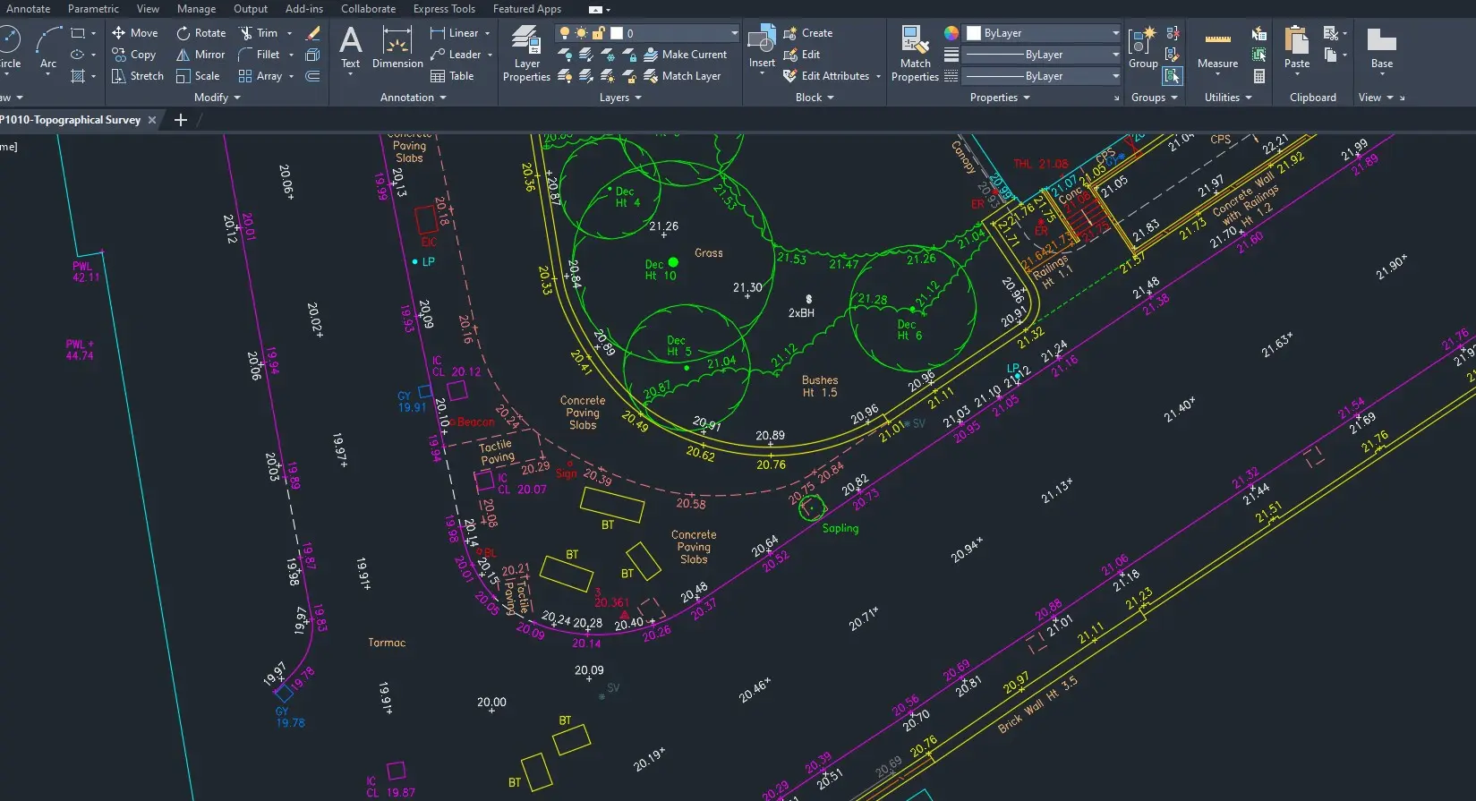


What Our Topographical Surveys Provide
Our topographical survey services deliver precise measurements of all relevant land and site features, including:
-
Levels, spot heights and contours
Accurate levels, spot heights, contours and terrain structure suitable for design and drainage. -
Boundaries and title extents
Boundaries, title extents and fence lines clearly shown for ownership and due diligence. -
Buildings, walls and structures
Existing buildings, retaining walls and structural elements are mapped accurately.
-
Kerbs, roads and hardstanding
Roads, pavements, car parks and hardstanding surveyed in detail. -
Trees, landscaping and vegetation
Trees and vegetation recorded with positions and canopy data. -
Surface drainage and utilities
Drainage features, utility covers and markers captured for design impact.
All mapping is issued on coordinated grids suitable for planning, architectural design, engineering design and construction.
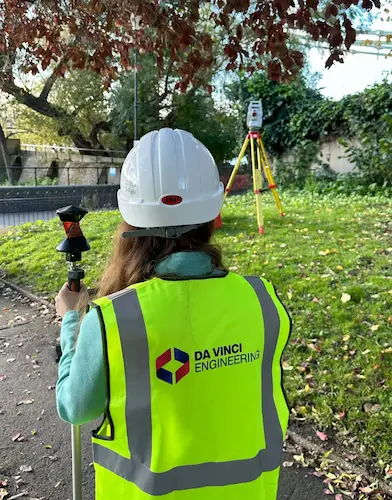
Topographical survey in London using Leica total station equipment.
Topographical Survey Workflow
Scope & Requirements
Survey objectives, land coverage, level of detail and deliverables are defined in line with your project and construction needs.
On-Site Topographical Survey
Control is established and features are captured using Leica GNSS, GPS robotic instruments and 3D laser scanning where required. This provides high-precision land data suitable for 3D modelling, 3D topographical survey outputs and detailed design.
Data Processing & Quality Review
Survey data is processed in-house, checked against field records and specifications, and reviewed to maintain accuracy and consistency at the highest standards.
Final Deliverables
We issue DWG CAD drawings, PDFs, 3D topographical models and terrain data — clean, coordinated and ready for immediate use by architects, engineers and construction teams within design and planning workflows.
Applications of Our Topographical Survey Services
Our topographical surveys in London and across the UK are used to support a wide range of development, design, and infrastructure projects, including:
-
Planning submissions and feasibility studies
Base mapping and site data for planning applications, pre-application enquiries, and early-stage feasibility assessments. -
Architectural and engineering design
Accurate measured site information to inform the design of new-builds, extensions, refurbishments, and external works. -
Redevelopment and construction planning
Detailed data to support redevelopment schemes, construction logistics, temporary works, site access, and external level design. -
Drainage design and flood risk assessment
Elevation, level, and contour data required for drainage strategies, flood risk assessments, and infrastructure layouts. -
Landscape architecture and urban planning
Reliable landform and feature data for landscape design, public realm improvements, and wider urban planning schemes. -
Site feasibility and asset management
Topographical information to support land appraisal, site acquisition, feasibility studies, and ongoing asset management.
Accurate topographical survey data at the outset of a project enables better planning, reduces risk, and supports informed design decisions throughout the entire construction project lifecycle.
Why Clients Choose Us as Their Topographical Surveyor
Technical expertise in land surveying
Specialist technical expertise in topographical survey, land data and construction workflows.
Structured CAD and topographical outputs
Structured CAD drawings and clear topographical survey outputs that integrate smoothly with architects’ and engineers’ design processes.
Consistent methodology and QA
Consistent methodology focused on high-precision land data, internal QA and clear reporting standards.
Efficient programming and delivery
Efficient survey programming, fast mobilisation and delivery aligned with construction timelines and planning deadlines.
Transparent, competitive pricing
Transparent pricing based on clearly defined scope and deliverables, with competitive fees on London and UK projects.
Practical understanding of design and construction
Practical understanding of how design and construction teams use topographical survey data, so information is issued in the most useful formats.
We operate as a dedicated topographical survey partner, combining survey accuracy with practical design and construction expertise so information integrates directly into professional workflows.
Output Standards
Our topographical survey outputs are clear, consistent, and professionally structured for immediate use by architects, engineers, consultants, and construction teams.
DWG CAD drawings with scaled PDF deliverables
Issued as fully layered DWG files with scaled PDF copies for use by design teams,
consultants, and clients.
Appropriate professional drawing scales
Typical scales such as 1:100, 1:200, or 1:500, selected to suit architectural,
engineering, and planning requirements.
OS-aligned grids and reference systems
Drawings aligned to Ordnance Survey coordinates to ensure accurate positioning,
coordination, and setting-out on site.
Clear layering, line work, and annotation
Structured CAD layering, consistent line weights, and clear annotation for
efficient use across design and construction workflows.
Extended mapping options
Survey coverage can extend beyond the site boundary where visibility, access,
or design requirements demand a wider context.
Internal quality assurance checks
All survey data undergo internal checks on control, levels, and accuracy to
maintain high precision and the highest professional standards.
These outputs are suitable for use in 3D modelling, BIM workflows, planning submissions, and detailed architectural and engineering design.
Internal Quality Checks
All survey control, levels and captured data are subject to internal quality checks to maintain high precision and the highest standards of topographical survey data.
These checks ensure our outputs are reliable, consistent and suitable for use in 3D modelling, BIM workflows, planning drawings and detailed design.
Topographical Survey Services Pricing
Project-specific - Transparent fees
Our fees are project-specific and transparent. Pricing reflects site size, access constraints, land complexity, and the required level of detail, ensuring a competitive and fair quotation for each project.
Send us your site address and a brief scope of works to receive a tailored quotation from qualified topographical surveyors in London.
Schedule Your Topographical Survey
We offer flexible survey scheduling to support planning, design and construction programmes, with fast mobilisation and reliable delivery.
-
Short-notice and next-day appointments
Short-notice survey bookings are available, including next-day site visits on many projects, with typical drawing delivery within 24–48 hours. -
Competitive, like-for-like pricing
We offer competitive pricing and can match like-for-like quotations where scope and deliverables are directly comparable. -
Free, no-obligation quote
Send your site address and a brief scope of works to receive a tailored, free no-obligation quotation and reserve the next available survey slot.
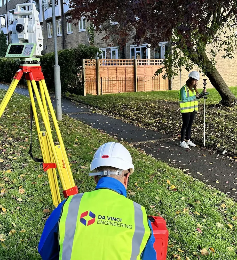
Da Vinci Engineering surveyor in London carrying out a topographical survey with a Leica total station.